Hadrian Wall or Maginot Line...

rittmeister

trekkie in residence
Staff member
Administrator
Joined
May 12, 2019
Messages
5,208
Reaction score
3,455
What tanks?
those that weren't deployed 'cause adolf had reserved their use and nobody dared to wake him up - if rommel had been in france he would have just ordered them to the front
 

5fish

Well-Known Member
Joined
Jul 28, 2019
Messages
10,699
Reaction score
4,553

5fish

Well-Known Member
Joined
Jul 28, 2019
Messages
10,699
Reaction score
4,553
It looks like the Brits have more than Haderain Wall... It has King Offa Dyke...


Offa's Dyke (Welsh: Clawdd Offa) is a large linear earthwork that roughly follows the current border between England and Wales. The structure is named after Offa, the Anglo-Saxon king of Mercia from AD 757 until 796, who is traditionally believed to have ordered its construction.

Here is a link that shows where it is...

 
Last edited:

Jim Klag

Ike the moderator
Staff member
Moderator
Joined
May 12, 2019
Messages
3,690
Reaction score
2,296
It looks like the Brits have more than Haderain Wall... It has King Offa Dyke...


Offa's Dyke (Welsh: Clawdd Offa) is a large linear earthwork that roughly follows the current border between England and Wales. The structure is named after Offa, the Anglo-Saxon king of Mercia from AD 757 until 796, who is traditionally believed to have ordered its construction.

Here is a link that shows where it is...

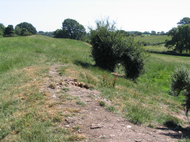
The guy who would like this article is @alexjack our resident Welshman.
 

5fish

Well-Known Member
Joined
Jul 28, 2019
Messages
10,699
Reaction score
4,553
Look at this another dyke built in Wales across from Offa Dyke... call Wat Dyke...


Wat's Dyke (Welsh: Clawdd Wat) is a 40-mile (64 km) earthwork running through the northern Welsh Marches from Basingwerk Abbey on the River Dee estuary, passing east of Oswestry and on to Maesbury in Shropshire, England. It runs generally parallel to Offa's Dyke, sometimes within a few yards but never more than three miles (5 km) away. It now appears insignificant, sometimes a raised hedgerow and in other places is now no more than a cropmark, the ditch long since filled in and the bank ploughed away, but originally it was a considerable construction, considered to be strategically more sophisticated than Offa's Dyke.[1] The date of construction is disputed, ranging from sub-Roman to the early ninth century.

I think @alexjack like to see this as well...

1600819880961.png
 

alexjack

zhe welsh wizard
Joined
May 17, 2019
Messages
184
Reaction score
193
Look at this another dyke built in Wales across from Offa Dyke... call Wat Dyke...


Wat's Dyke (Welsh: Clawdd Wat) is a 40-mile (64 km) earthwork running through the northern Welsh Marches from Basingwerk Abbey on the River Dee estuary, passing east of Oswestry and on to Maesbury in Shropshire, England. It runs generally parallel to Offa's Dyke, sometimes within a few yards but never more than three miles (5 km) away. It now appears insignificant, sometimes a raised hedgerow and in other places is now no more than a cropmark, the ditch long since filled in and the bank ploughed away, but originally it was a considerable construction, considered to be strategically more sophisticated than Offa's Dyke.[1] The date of construction is disputed, ranging from sub-Roman to the early ninth century.

I think @alexjack like to see this as well...

View attachment 3322
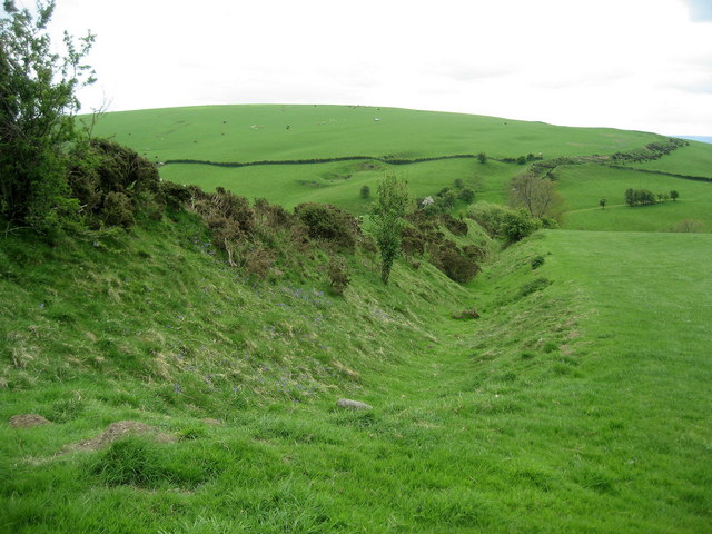
Thanks for posting that 5fish. That border has always been a problem.
 

5fish

Well-Known Member
Joined
Jul 28, 2019
Messages
10,699
Reaction score
4,553
We have a wall here in North America long before our border wall its over by Silicone valley... maybe @diane knows about it...


8. Berkeley Mystery Walls
SAN FRANCISCO, CALIFORNIA
One of many old stone walls found around the southern and eastern San Francisco Bay in California.One of many old stone walls found around the southern and eastern San Francisco Bay in California. ELF/CC BY-SA 4.0
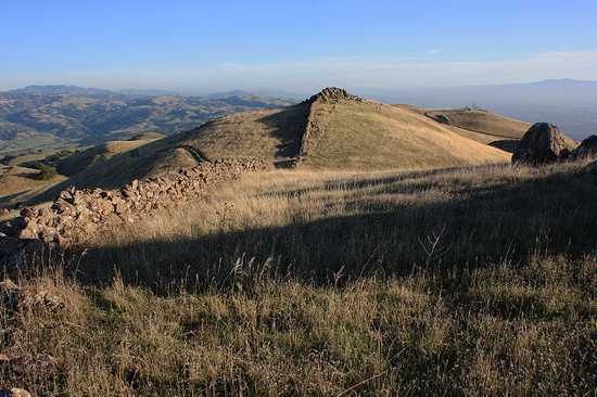
Also known as the East Bay Walls, the Berkeley Mystery Walls are a series of stone walls running in a rough path through the Bay Area of California, from Berkeley to San Jose. Their purpose is unknown; they’re too low to be a defensive wall, there are gaps in the structures, and at one point they form ornamental spiral patterns. It’s also unclear who made them. Early Spanish settlers found them already standing, and the local Ohlone people reported they’d always seen them there, too.
Whenever they were built, it was long enough ago for sections of the stones to have sunk into the earth. A 1904 archaeologist suggested they were built by Mongolian sailors who’d come to the California coast well before the time of Columbus, but his theory seems to have been based more on wishful thinking than scholarship.


Snip... here is another article with more photos of the wall...


snip...

THERE ARE REMNANTS OF ANCIENT stone walls all over the East Bay, and no one knows how old they are, who built them, or why. Though people have been pondering the enigma of the Berkeley Mystery Walls for well over a hundred years, no conclusions have been reached, and despite wild speculation, no serious scholarly study has ever been undertaken.

Stretching for over 50 miles, the East Bay “Mystery Walls” are found up and down the hills of the East Bay from Berkeley to San Jose. The stone walls are up to five feet tall in places, and are constructed from boulders of varying sizes, some weighing up to a ton. The walls run in broken sections, anywhere from a few meters to half a mile in length, and are placed in unlikely and inaccessible places. They seem to serve no known purpose. They are not continuous or high enough to act as an enclosure, or measure of defense. They are clearly, visibly, very old. The heavy stones have sunk deep into the ground, and they are overgrown with lichen. After meandering throughout the Oakland hills, they head inland towards Mt. Diablo where they lead to mysterious stone circles, up to 30 feet in diameter. In one place the walls form a spiral 200 feet wide that circles a large boulder.
 

diane

that gal
Joined
Mar 18, 2020
Messages
2,416
Reaction score
3,050
:D The Berkeley Walls are all over California, not just Central. The Shasta have a lot of them in Shasta Valley - for some miraculous reason the Berkeley ones have not been destroyed by ranchers, farmers, etc. Our traditions are oral and that is kind of a bad look-out when the historians die off before they can pass on the information, so we only have fuzzy ideas of what are ancestors were up to. Walls do not mean the same thing - they aren't physical barriers and have a spiritual meaning. The old time religion took quite a beating, especially since it was outlawed, so we're as much in the dark now as anybody else. One thing - the walls in the valley have to do with astronomy. (The hunting blinds are fairly easy to tell.)
 

5fish

Well-Known Member
Joined
Jul 28, 2019
Messages
10,699
Reaction score
4,553
I have found a modern wall being built in Africa will it succeed? Its called the Great Green Wall trying to Keep the Great Sahara desert from advancing any further south...

https://www.greatgreenwall.org/about-great-green-wall

snip...

The Great Green Wall is an African-led movement with an epic ambition to grow an 8,000km natural wonder of the world across the entire width of Africa. A decade in and roughly 15% underway, the initiative is already bringing life back to Africa’s degraded landscapes at an unprecedented scale, providing food security, jobs and a reason to stay for the millions who live along its path.

The Wall promises to be a compelling solution to the many urgent threats not only facing the African Continent, but the global community as a whole – notably climate change, drought, famine, conflict and migration. Once complete, the Great Green Wall will be the largest living structure on the planet, 3 times the size of the Great Barrier Reef.


The Great Green Wall is failing?


snip...

It was a simple plan to combat a complex problem. The plan: plant a Great Green Wall of trees 10 miles wide and 4,350 miles long, bisecting a dozen countries from Senegal in the west to Djibouti in the east. The problem: the creeping desertification across Africa.

snip...

Planting trees across the Sahel, the arid savanna on the south border of the Sahara Desert, had no chance to succeed. There was little funding. There was no science suggesting it would work. Moreover, the desert was not actually moving south; instead, overuse was denuding the land. Large chunks of the proposed "wall" were uninhabited, meaning no one would be there to care for the saplings.

snip...

Slowly, the idea of a Great Green Wall has changed into a program centered around indigenous land use techniques, not planting a forest on the edge of a desert. The African Union and the United Nation's Food and Agriculture Organization now refer to it as "Africa’s flagship initiative to combat land degradation, desertification and drought." Incredibly, the Great Green Wall—or some form of it—appears to be working.


The rest of the article about how the Great Green Wall is being built differently...


5fish

Well-Known Member
Joined
Jul 28, 2019
Messages
10,699
Reaction score
4,553
In 2007, the African Union proposed planting a mosaic of trees, shrubs, and grasses along an 8000-kilometer-long corridor across the continent by 2030. The project has made modest headway since then, but new funding could help.

1616353525774.png
 

rittmeister

trekkie in residence
Staff member
Administrator
Joined
May 12, 2019
Messages
5,208
Reaction score
3,455

rittmeister

trekkie in residence
Staff member
Administrator
Joined
May 12, 2019
Messages
5,208
Reaction score
3,455
and zhe people who innocently trying to collect some fire wood? how the hell will they water the project?

ah pipe line same prob as with fuel piplines: Guy+bucket+drill
try reading the page

for starters: solar panels and electric stoves shouldn't be a problem - don't think of it as a guy with a shovel and three saplings
 

5fish

Well-Known Member
Joined
Jul 28, 2019
Messages
10,699
Reaction score
4,553
, just some innocent desert
That is growing, rarely do things grow in a desert...

The Sahara Desert is expanding
New study finds that the world's largest desert grew by 10 percent since 1920, due in part to climate change
Date:March 29, 2018Source:University of MarylandSummary:The Sahara Desert has expanded by about 10 percent since 1920, according to a new study. The research is the first to assess century-scale changes to the boundaries of the world's largest desert and suggests that other deserts could be expanding as well.

https://www.sciencedaily.com/releases/2018/03/180329141035.htm


There is this report saying well all is okay... written a year later...

The Great Green Wall — a project that aims to plant a vast wall of trees across North Africa — cannot prevent an expansion of the Sahara. Nor can planting trees in semi-arid regions in general increase rainfall.


snip...

First of all, the Sahara is not expanding into the rest of Africa. Drought in the Sahel in the 1970s and 1980s made it look like the desert was expanding, because the reduction of rainfall at the desert margin (the Sahel) caused a reduction in vegetation. However, since the advent of satellite observations of land cover in the early 1980s, we know that how far north into the desert vegetation grows depends on how much it rains at the edge of the desert. How much it rains in the Sahel over decades to centuries is primarily controlled by very large-scale influences, such as the temperatures of the global oceans, not by how much vegetation there is.
 

5fish

Well-Known Member
Joined
Jul 28, 2019
Messages
10,699
Reaction score
4,553
I found a article with pictures comparing ancient walls between South America and the Mediterranean... They have a list and a picture of each type of walls built by ancient man...


snip...

A survey carried out on dry-stone walls of the central Andes allowed us to recognize that those walls were erected using a unit of measurement of 1.536 cm, the same that was used in the construction of similar works in Italy and Greece. In both areas the same techniques were applied, but only in South America there are signs of an evolution with clear transitions between them.
 

5fish

Well-Known Member
Joined
Jul 28, 2019
Messages
10,699
Reaction score
4,553
OMG @rittmeister and @Wehrkraftzersetzer you can drive the Roman Limes of Germany... Time for a weekend drive... Look up your Roman heritage... and how many Roman ruins have you been too...

https://europe.stripes.com/travel/ruins-roman-empire-germany

The German Limes

Using the Danube, Rhine and North Sea as natural boundaries, the Romans built connecting fortified walls, called Limes Germanicus, to create territories that would help control their settlements from invasion. A 700-kilometer tourist road, called the German Limes Road, was built to allow tourists to follow the path of the limes, now UNESCO World Heritage Sites. It runs from Bad Hönningen on the banks of the Rhine through Rhineland-Palatinate, Hesse, Baden-Wurttemberg and Bavaria to Regensburg on the Danube. Along the road are several points of interest about Roman culture and history in Germany, including an original Roman fort, in Saalburg near Bad Homburg. For more information, visit the sites www.limesstrasse.de and whc.unesco.org.

Once you’ve navigated these locations, you may want to start creating a new list of Roman sites to see, perhaps in neighboring France. A good place to start would be in Nîmes; the city’s amphitheatre, La Maison Carrée, and Pont du Gard aqueduct rival exhibits in Rome … but we’ll save that for another story.
 

5fish

Well-Known Member
Joined
Jul 28, 2019
Messages
10,699
Reaction score
4,553
Here a wiki take on the German Limes...


snip...

The Limes Germanicus (Latin for Germanic frontier) is the name given in modern times to a line of frontier (limes) fortifications that bounded the ancient Roman provinces of Germania Inferior, Germania Superior and Raetia, dividing the Roman Empire and the unsubdued Germanic tribes from the years 83 to about 260 AD. The Limes used either a natural boundary such as a river or typically an earth bank and ditch with a wooden palisade and watchtowers at intervals. A system of linked forts was built behind the Limes.
 

rittmeister

trekkie in residence
Staff member
Administrator
Joined
May 12, 2019
Messages
5,208
Reaction score
3,455
OMG @rittmeister and @Wehrkraftzersetzer you can drive the Roman Limes of Germany... Time for a weekend drive... Look up your Roman heritage... and how many Roman ruins have you been too...

https://europe.stripes.com/travel/ruins-roman-empire-germany

The German Limes

Using the Danube, Rhine and North Sea as natural boundaries, the Romans built connecting fortified walls, called Limes Germanicus, to create territories that would help control their settlements from invasion. A 700-kilometer tourist road, called the German Limes Road, was built to allow tourists to follow the path of the limes, now UNESCO World Heritage Sites. It runs from Bad Hönningen on the banks of the Rhine through Rhineland-Palatinate, Hesse, Baden-Wurttemberg and Bavaria to Regensburg on the Danube. Along the road are several points of interest about Roman culture and history in Germany, including an original Roman fort, in Saalburg near Bad Homburg. For more information, visit the sites www.limesstrasse.de and whc.unesco.org.

Once you’ve navigated these locations, you may want to start creating a new list of Roman sites to see, perhaps in neighboring France. A good place to start would be in Nîmes; the city’s amphitheatre, La Maison Carrée, and Pont du Gard aqueduct rival exhibits in Rome … but we’ll save that for another story.
what gives you the idea i haven't done that? but i did it on foot (with some friends over a couple of years)
 
Top